EUDR Deforestation Risk Assessment with Multi-Source Satellite Analysis

Built for accuracy at scale.

Fully integrated, in-house satellite analysis with multiple sources and cross-validation for maximum accuracy.
0m+

ha
analyzed

0 EUDR commodities

Any sourcing country.

Image

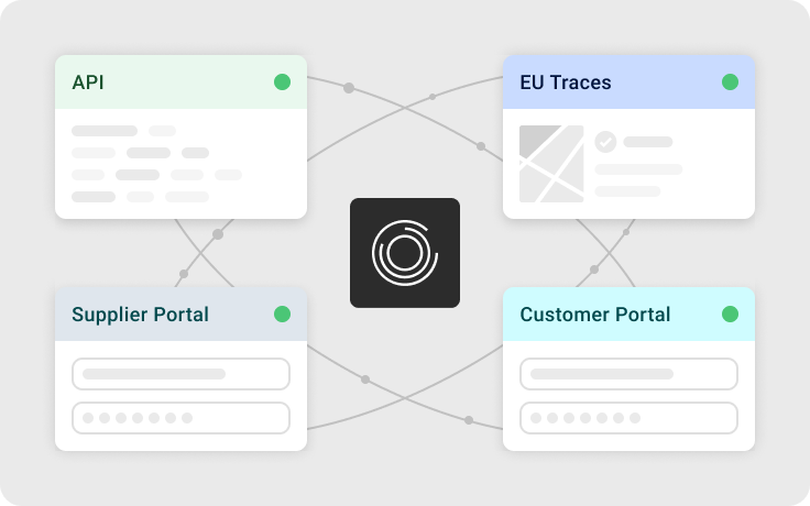
Software trusted by 800+ companies

Image
Image
Image
Image
Image
Image
Image
Image

Why accurate satellite analysis matters for your EUDR compliance.

EUDR compliance requires companies to demonstrate that commodities across all origins are not associated with deforestation or forest degradation after December 2020. How you assess each plot of land is where most challenges arise:

  • - Manual checks are not feasible across all sourcing origins and with frequent updates due to the high workload and required specialized knowledge
  • - Public maps have low accuracy and are not always aligned with EUDR definitions
  • - Audits require defensible risk analysis and management practices

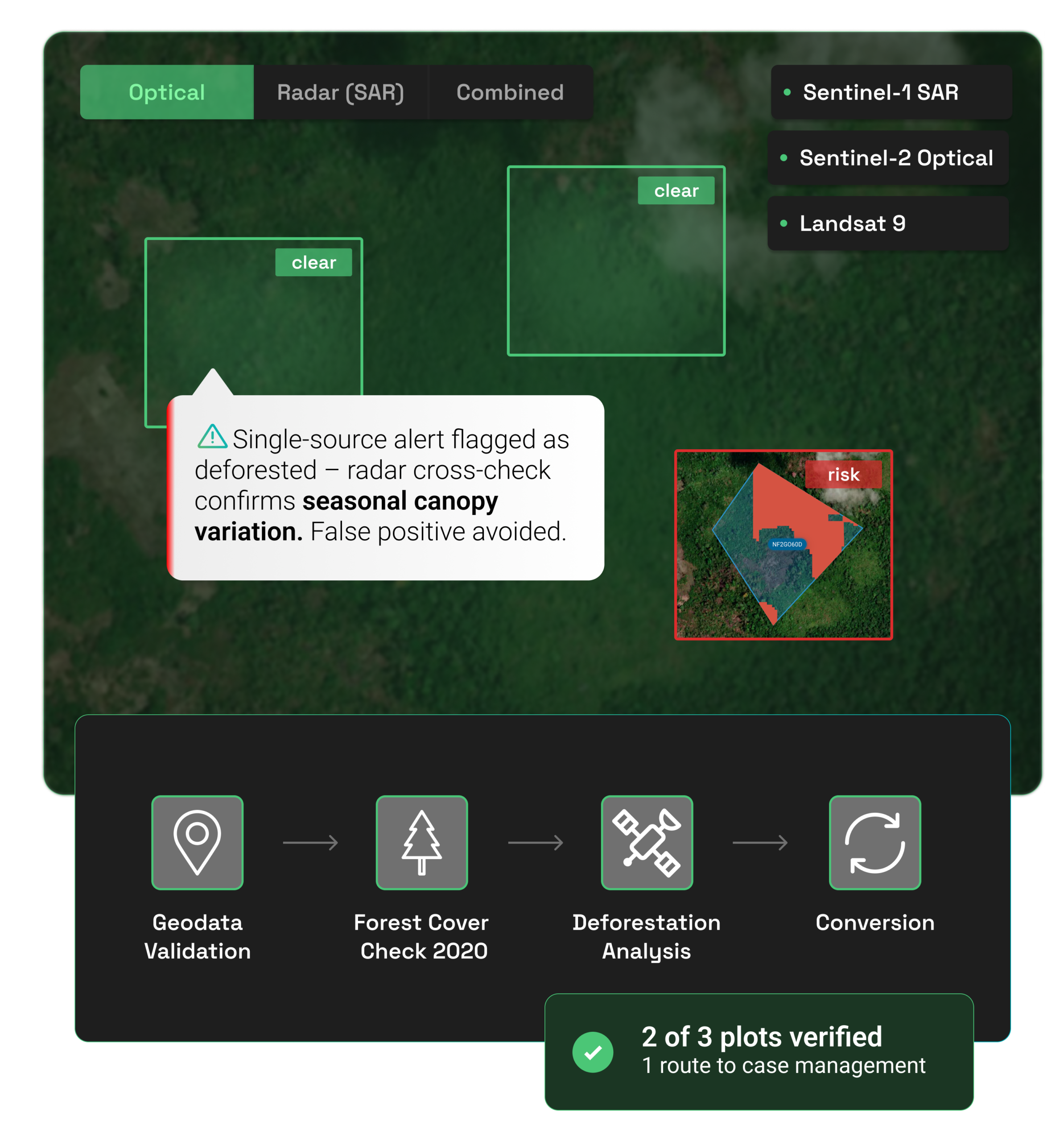
A standardized, transparent, and scalable risk assessment approach is therefore essential.

Request a demo

Typical risk assement challenges

Image

Typical challenge

Manual plot checks across many origins

Inconsistent manual assesments are hard to defend

High-risk cases are hard to prioritize due to too many plot checks

Local factors and weather patterns make visual identification difficult

Relying on a single satellite data source with no cross-validation

Separate tools for analysis and mitigation

Image

osapiens approach

Automated, satellite-based assessment at scale

Unified, EUDR-aligned risk logic validated by expert-reviewed satellite data

Automated analysis allows risk-based prioritizaiton

Combined radar and optical satellite analysis with persistent change detection

Multi-source analysis combining radar and optical satellite data with EUDR specific validation logic

Risk results linked to case management and ERP systems

Image

Operational outcome

Less time spent requesting and validating plot data

Consistent and defensible compliance decisions

Focus only on high-risk plots and suppliers

High-precision deforestation risk detection across ecoregions and commodities, minimizing false positives

Transparent, traceable and explainable compliance decisions

Faster follow-up and collaboration on high-risk cases


Data extraction

Validation & enrichment

Risk assessment

Documentation

Audit readiness

Image

Typical Manual Process

Manual CSV/Excel exports from multiple systems

Spreadsheet-based checks, prone to errors

Manual scoring based on incomplete data

PDF reports compiled manually

Time-consuming preparation, data gaps


Data extraction

Validation & enrichment

Risk assessment

Documentation

Audit readiness

Image

Typical Manual Process

Automated API sync with real-time data access. Native SAP Integration available!

Automated validation rules and data enrichment

AI-powered risk scoring with complete data sets

Automated documentation with version control

Instant audit trail, complete data lineage


Data extraction

Validation & enrichment

Risk assessment

Documentation

Audit readiness

Benefits for your Company

Faster access to required EUDR data

Risk-based focus on high-impact plots and suppliers

Unified risk view across all EUDR dimensions

Audit-ready reports on demand

End-to-end data transparency across ERP and osapiens HUB

Image

Reduced human error, faster processes, consistent and auditable data flow

Benefit from working with the #1 market leading software solution for automating EUDR


Image

Audit-ready by design

Every risk assessment is fully traceable and audit-ready with consistent risk management across time, shipments, and supply chains.
Learn More
Image

Fewer false positives

Multi-source risk analysis with cross-validation catches high risk cases reliably and accurately. Radar confirms and increases confidence in tropical regions.
Learn More
Image

90% faster risk assessment

Automated satellite analysis replaces manual plot checks. Your team focuses only on the cases that are high risk cases.
Learn More
Image

Human in the loop

Our analysis toolkit empowers users to inspect high-risk cases, verify with geospatial data, and collaborate with suppliers on case resolution.
Learn More

Understanding deforestation risk logic

Every plot of land undergoes a thorough process closely aligned with the EUDR requirements:


Logic behind osapiens' deforestation analysis.

Handling high risk cases with the osapiens HUB for EUDR

Turn risk signals into audit-ready decisions with built in case-management.

  • Case management built-in
  • Supplier collaboration via (free) Supplier Portal
  • Full audit logs

Audit-ready documentation

via audit-logs within case management.

Reduced manual effort

due to highlighting only relevant high-risk cases.

Fast risk mitigation

by using standardized workflows and a central platform to collaborate on high risk cases with your suppliers.

Fewer false postives

over time due to case management. 

Resource Center

Further Reading & Ressources

Image

Webinar Series

EUDR for First Operators - a practical webinar series for importers

Register Now
Image

Guide

TRACES NT Made Simple – Your Guide to TRACES Login & Registration

Learn More
Image

Guide

EUDR Guide – A Simple, Quick and Scalable Approach to EUDR

Learn More
Image

Guide

EUDR For Importers Guide & Checklist

Learn More
Image

Webinar Series

EUDR Readiness 2026 - a living webinar series

Register Now